Checked
History of Brampton, Ontario
Brampton, Ontario, Canada
A short history of Brampton, Ontario: the Mississaugas of the Credit and Treaty 19, Buffy's Corners, the Peel county town, the Dale Estate greenhouses, Bramalea, the 1974 city and recent changes in Peel.
Key information
Brampton is on the traditional territory of the Mississaugas of the Credit, Haudenosaunee and Wendat, and the land was surrendered to the Crown in Treaty 19, the Ajetance Purchase of 1818. The settlement at Buffy's Corners became the village of Brampton in 1853, a town in 1873 and the City of Brampton in 1974.
On this page
Indigenous peoples and the land
The City of Brampton's land acknowledgement says the city is on the traditional territories of the Mississaugas of the Credit, Haudenosaunee and Wendat Nations, who have called this land home since time immemorial. It recognizes the Mississaugas of the Credit as the original rights holders and the signatories of Treaty 19.
Indigenous peoples have lived near the Credit and Humber rivers for thousands of years. The Wendat farmed, fished, hunted and lived in longhouses. After 17th-century wars and European diseases emptied much of the region, the Haudenosaunee left the Humber watershed in the early 1700s, and the Mississaugas, an Anishinaabe people, moved into the Brampton area.
Sources: City of Brampton: Land Acknowledgement · The Canadian Encyclopedia: Brampton
Treaty 19, the Ajetance Purchase (1818)
On October 28, 1818, Chief James Ajetance and other Mississauga leaders signed Treaty 19 with the British Crown. It surrendered about 2,622 square kilometres north of today's Eglinton Avenue, covering most of what is now the Region of Peel, including all of Brampton. In return the Mississaugas of the Credit were to receive goods worth 522 pounds and 10 shillings every year.
The land was surveyed and opened to settlers in 1819 as the New Survey, divided into the townships of Toronto, Chinguacousy, Caledon, Albion and Toronto Gore. In 1847 the Mississaugas of the Credit moved to land near Hagersville, next to Six Nations of the Grand River, where the First Nation lives today.
Sources: The Canadian Encyclopedia: Brampton · Heritage Mississauga: Mississauga's history (Treaty 19 and the New Survey) · City of Brampton: Land Acknowledgement · Mississaugas of the Credit First Nation: Community profile
From Buffy's Corners to a village (1819 to 1866)
Richard Bristol, a British surveyor, laid out Chinguacousy Township in 1819, and English settlers began arriving in 1820. In the 1830s a small settlement grew at the crossing of Hurontario and Queen streets, on the floodplain of Etobicoke Creek. It was known as Buffy's Corners.
When it was incorporated as a village in 1853, it took the name Brampton, after a town in Cumberland, England. The Grand Trunk Railway arrived in 1858. Nearby hamlets such as Churchville, Huttonville, Snelgrove, Castlemore and Stanley's Mills grew up around mills and crossroads.
Sources: The Canadian Encyclopedia: Brampton
The Peel county town (1867 to 1945)
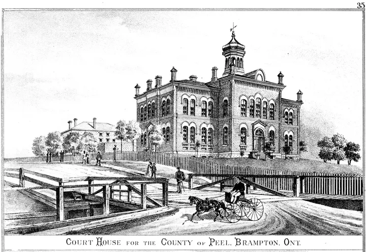
In 1867 voters chose Brampton as the seat of Peel County's government. The Peel County Courthouse and Jail opened that year, and a Registry Office followed in 1890. Brampton became a town in 1873.
Being the county town and having a railway brought business. Local firms included the Haggert Bros. farm machinery foundry, Hewetson Shoes, Gummed Papers and Dixie Cup. The Credit Valley Railway built a station in 1880, replaced in 1902 by a brick and stone CPR station. In the 1920s the Dale Estate greenhouses produced nearly half of Canada's cut flowers.
Sources: The Canadian Encyclopedia: Brampton · PAMA: History · City of Brampton: CPR Station
Suburbs, Bramalea and the new city (1946 to 1974)
After the Second World War, new housing and industry spread out from the old town. Bramalea was planned as a separate "satellite city", and its first houses were built in 1959.
In the 1960s the province reviewed local government in fast-growing Peel County, which then had 10 municipal governments. In 1974 it replaced them with three: Brampton, Mississauga and Caledon. The new City of Brampton joined the Town of Brampton, Toronto Gore Township, the southern half of Chinguacousy Township and part of the Town of Mississauga.
Sources: The Canadian Encyclopedia: Brampton
From bedroom community to big city (1974 to today)
Farmland inside the new city filled with subdivisions, and Brampton became known as a commuter suburb even though it kept major industry. The Dale Estate greenhouses closed in 1980. The CPR station, which saw its last passenger train in 1970, was saved from demolition and later rebuilt at Mount Pleasant Village.
Immigration, especially from South Asia, made Brampton one of the most diverse cities in Canada. Brampton Civic Hospital opened in 2007 and Züm rapid buses started in 2010. The population grew from 341,463 in 2001 to an estimated 777,759 in 2025, and Toronto Metropolitan University opened its School of Medicine in Brampton in 2025.
In 2023 the province planned to dissolve the Region of Peel, then reversed course in December 2023. Brampton took over land use planning on July 1, 2024. Under the Peel Transition Implementation Act, 2025, the province intends regional roads to move to the City on July 1, 2027 and waste collection on October 1, 2027. Patrick Brown, first elected mayor in 2018, leads the 2026 to 2030 council.
Sources: The Canadian Encyclopedia: Brampton · City of Brampton: CPR Station · Statistics Canada: Census Profile, 2021 Census, Brampton (City) · William Osler Health System: Brampton Civic Hospital · Brampton Transit: Fast facts · Statistics Canada: Population estimates, July 1, by census subdivision (Table 17-10-0155-01) · Toronto Metropolitan University: School of Medicine, our journey · Region of Peel: Provincial review update · City of Brampton: Province announces changes to key public works in Brampton (December 13, 2024) · Environmental Registry of Ontario: Peel Transition Implementation Act, 2025, decision (ERO 025-0570) · City of Brampton: Brampton City Council 2026-2030
Historic places you can still visit
- Peel County Courthouse and Jail (1867) and Registry Office (1890), now PAMA, in downtown Brampton.
- The rebuilt CPR station (1902) at Mount Pleasant Village, now part of a library and community centre.
- Historic Bovaird House, a mid-19th-century Georgian farmhouse, closed while the City prepares to reopen it.
- The Pendergast Log House, a mid-1800s log home being moved to the Bovaird House grounds.
- Main Street South, a tree-lined street of early 20th-century homes studied as a heritage conservation district.
Sources: PAMA: History · City of Brampton: CPR Station · City of Brampton: Historic Bovaird House · City of Brampton: Pendergast Log House · City of Brampton: Main Street South Heritage Conservation District
Brampton history timeline
| Year | Event |
|---|---|
| Early 1700s | The Mississaugas move into the Brampton area |
| 1818 | Treaty 19 (Ajetance Purchase) signed on October 28 |
| 1819 | Chinguacousy Township surveyed; land opened to settlers |
| 1830s | Settlement grows at Buffy's Corners |
| 1847 | Mississaugas of the Credit move to land near Hagersville |
| 1853 | Village of Brampton incorporated |
| 1858 | Grand Trunk Railway arrives |
| 1867 | Brampton chosen as Peel county town; courthouse and jail open |
| 1871 | Brampton Excelsiors lacrosse club formed |
| 1873 | Brampton becomes a town |
| 1890 | Peel County Registry Office built |
| 1902 | New CPR station built |
| 1920s | Dale Estate grows nearly half of Canada's cut flowers |
| 1959 | First houses built in Bramalea |
| 1970 | Last CP passenger train leaves Brampton station |
| 1974 | City of Brampton formed |
| 1980 | Dale Estate flower business closes |
| 2007 | Brampton Civic Hospital opens |
| 2010 | Züm rapid bus service launches |
| 2021 | Census counts 656,480 people |
| 2024 | City takes over land use planning from Peel on July 1 |
| 2025 | TMU School of Medicine opens; Peel Transition Implementation Act, 2025 receives Royal Assent |
| 2027 | Regional roads (July 1) and waste collection (October 1) scheduled to move to the City |
Sources: The Canadian Encyclopedia: Brampton · Heritage Mississauga: Mississauga's history (Treaty 19 and the New Survey) · Mississaugas of the Credit First Nation: Community profile · PAMA: History · City of Brampton: CPR Station · William Osler Health System: Brampton Civic Hospital · Brampton Transit: Fast facts · Statistics Canada: Census Profile, 2021 Census, Brampton (City) · Region of Peel: Provincial review update · Toronto Metropolitan University: School of Medicine, our journey · Environmental Registry of Ontario: Peel Transition Implementation Act, 2025, decision (ERO 025-0570)
Questions and answers
When was Brampton founded?
A settlement grew at Buffy's Corners in the 1830s. It became the Village of Brampton in 1853, a town in 1873 and a city in 1974.
Whose traditional territory is Brampton on?
The City says Brampton is on the traditional territories of the Mississaugas of the Credit, Haudenosaunee and Wendat Nations.
What treaty covers Brampton?
Treaty 19, the Ajetance Purchase, signed in 1818 by the Mississaugas of the Credit and the Crown.
Who signed Treaty 19?
James Ajetance, chief of the Mississaugas of the Credit, signed for the Mississaugas with the British colonial government.
When did Brampton become a city?
In 1974, when the province combined the Town of Brampton with Toronto Gore, southern Chinguacousy and part of Mississauga.
Why is Brampton the home of Peel's old courthouse?
In 1867 voters chose Brampton as the seat of Peel County, and the courthouse and jail opened that year.
Source: PAMA: History
What happened to the Dale Estate greenhouses?
Rising costs and competition from South America ended the business in 1980.
When was Bramalea built?
The first houses went up in 1959, and building continued into the 1980s.
Is the Region of Peel being dissolved?
No. The province dropped that plan in December 2023. Regional roads and waste collection are moving to Brampton, Mississauga and Caledon instead.